

Most requested
Services and information
Nautical charts
Purchase charts for navigational use or download sample charts in a variety of formats.
Nautical publications
We offer a wide range of nautical publications that are indispensable companions to charts, enhancing safety at sea.
Digital transformation
Major investments in advanced technologies and standards to ease a new era of marine navigation with digital products.
Data products and surveys
Download free 10m and 100m resolution bathymetry, learn about hydrographic surveys and the new S-100 standards under development.
Copyright and licensing
Licensing options, royalty rates, and authorized manufacturers for charts, data and publications for non-navigational use.
Arctic charting
Access the Arctic Voyage Planning Guide and other information about charting the Canadian Arctic.
Hydrography
The science of charting our waters, from data acquisition to data processing and management techniques.
Help and information
Information about the Canadian Hydrographic Service, frequently asked questions, and contact information.
Features
CHS Digital Transformation Initiative
At the Canadian Hydrographic Service, innovation is a guiding principle for the bold digital transformation initiative now underway.
CHS NONNA Version 3.0 Release
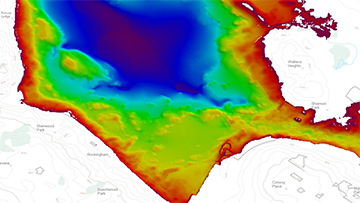
Client suggested enhancements have been implemented to the CHS NONNA Data Portal including migration to chart datum and enhanced tools for selecting and downloading large geographic areas.
2024 Tide Tables Available Now

Download your 2024 Canadian Tide and Current Tables now to help navigate safely through Canadian waters.
- Date modified: